The Area
Regional Information Overview
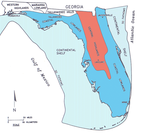 Bat Cave lies in North Central Florida, in the Central Highlands of the Atlantic Coastal
Plain (in red on the map) between the Northern Zone and the central Mid-Peninsula
Zone. (Map modified from White, 1964, 1970; Randazzo and Jones, 1997)
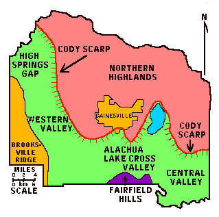
The general county topography is one of a lower, relatively flat limestone plain in the West and South, (in green on the map) and a relatively flat upland terrace, the Northern Highlands, (in pink on the map) in the North and East. The edge of the terrace is clearly delineated by the westward and southward-facing Cody Scarp. In the westernmost part of the county, including the Bat Cave area, land rises again in the Brooksville Ridge. (Map modified from Hoenstine et al., 1990)
The basic underpinnings of Florida are carbonate rocks, deposited on a shallow platform over tens of millions of years. These carbonates (mainly limestones and dolomites) formed in a warm shallow sea much like the Bahamas today, and form a major sequence of rocks, the youngest of which is the Ocala Limestone which is close to the surface in many areas of this region.
The later evolution of the Florida landscape and especially its karstification has had much to do with the tremendous climatic changes that took place during Cenozoic time. The Oligocene marked the beginning of a world wide cooling trend in the climate with the onset of a major glaciation in Antarctica. Later these glaciers will cover Greenland and eventually, in the Pliocene and Pleistocene will spread across North America and Europe and grow on mountain chains such as the Appalachians, Rockies, Alps and the Himalayas.
What do glaciers up North have to do with Florida?
 As the accumulation of glaciers withdraws increasing amounts of water from the oceans
to pile it up on land, the major effect of these glacial episodes is to expose the
carbonates (limestones and dolomites) that earlier formed in the seas of the Florida
Platform to a land environment, where they are subjected to weathering and erosion.
Thus glacial episodes, characterized by low stands of sea level, are times of erosion,
while high stands associated with interglacials generally are times of deposition
on the platform that flatten the sediments into terraces.
In this area, most of the Oligocene of Florida is gone, eroded by runoff and chemical action of infiltrating waters. Extensive dissolution within the exposed Eocene and older limestones later led to the present karst landscape. Miocene and later rises in sea-level led to the infilling and recovering of many of these karst features. Others filled in with sediments that washed in later. Frequently these infillings contain fossils that provide us with a great record of past life in Florida.
The Paleozoic Era
545-245 Million Years Ago
Florida is a Paleozoic immigrant
In Geology we now understand that the earth's outer layer, the lithosphere, is made of enormous slabs of rock some 60 miles thick that float on the layer beneath it, the asthenosphere. Those lithospheric slabs called plates, move, collide and separate, carrying their embedded continents with them. So, the history of Florida is also part of the history of plate movement.
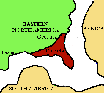
The specifics of the earliest history of Florida are lost in the mist of time. The oldest rocks that give us a record of the events of the earliest Earth are buried so deeply that they are just about inaccessible. We do know however that Florida's origin lies with that of the southern continents, more likely Africa. Florida fossils recovered from the Early Paleozoic (Ordovician Period to Devonian Period) rocks of Florida indicate that life here was closely related to life in rocks of the same age in South America, Africa and Eurasia, but NOT those of the US continent. In those days, Florida was part of a supercontinent we call Gondwanaland, that itself was formed by the earlier welding together of the southern continents, and not part of the northern group of continents called Laurasia.
Presumed location of Florida in Mississippian Time.
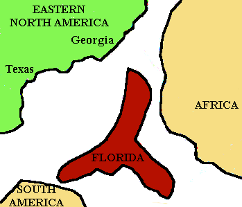
During Late Paleozoic time, Gondwanaland joined with Laurasia to form a single landmass that contained all the existing continents called Pangea. In the Pennsylvanian Period, somewhere around 300 MY ago, Florida was welded to the North American continent, certainly a fait accompli by Permian time.
Location of Florida by Pennsylvanian Time.
The Mesozoic Era
245-66.4 Million Years Ago
The Triassic Period
245-208 Million Years Ago
Throughout Triassic time, the Gulf Coastal area, including Florida, is land. In Late Triassic, the supercontinent Pangea begins to crack, break up and rift apart. Great grabens form, places where the lithosphere is foundering as this supercontinent rips apart. Late Triassic rocks mostly consist of sediments washing into those grabens from the bordering continents.
The Jurassic Period
208-144 Million Years Ago
In Early Jurassic time, the rocks are still terrestrial (deposited on land), representing continental sediments that are washing in the rift grabens that is formed as the Florida Platform separates from the African Plate. The Atlantic Ocean is opening. As North America also separates from South America, the Gulf of Mexico also begins to form, and sea water begins to flood the newly forming Gulf. Beginning in the Late Middle Jurassic, as the growing Gulf is intermittently shut off from oceanic waters, the waters of the Gulf evaporate, depositing over 3000' of evaporites (mainly salt). Eventually, by Late Jurassic, as the Gulf continues to open, circulation is no longer shut off and evaporites are no longer being deposited. Instead, carbonates (limestones and dolomites) are being put down as the first widespread ocean encroachment on land begins and continues into Cretaceous time.
The Cretaceous Period
144-66.4 Million Years Ago
In the Early Cretaceous, as seal level continues to rise, carbonate accumulation continues along the margin of the Florida platform. In the early part of the Middle Cretaceous, there is a rapid fall of sea level, soon followed by a rise, to eventually reach the one of the highest sea levels of all times. All along the East Coast, including Florida, a carbonate platform very similar to the Great Barrier Reef develops (except immensely larger) and limestone deposition and reef formation continue through most of the Cretaceous. Climates are warm, and in the Gulf of Mexico, warm currents flow from the Atlantic into the Pacific ocean.
This carbonate deposition ends before the end of the Cretaceous and there is about a 10 million year gap in the depositional record till deposition resumes in the Middle Paleocene. So, unfortunately, the Florida record is silent on the great extinction at the end of the Cretaceous and its causes.
The Cenozoic Era
66.4 Million Years Ago to now
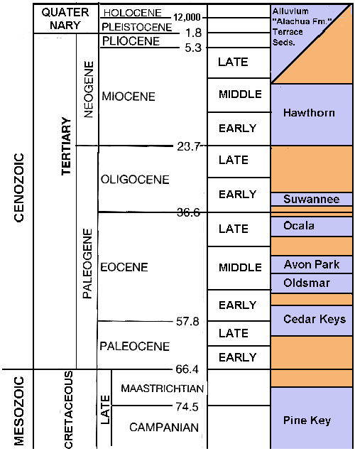
The Cenozoic Era is divided into two parts, the older and longer lasting Tertiary
Period and the Quaternary Period in which we live now. These Periods are in turn subdivided
into Epochs, based on the changing life patterns of the times.
The Tertiary Period
66.4-1.6 Million Years Ago
During the first 35 million years of the Tertiary, carbonate deposition is dominant on the Florida Platform. During the later Tertiary, several uplift periods in the Appalachians, and the associated erosion, provide clastic sediments that will reach Florida after the closing of the Suwanee Straight in the Oligocene. After the Oligocene, fluctuations in sea level, climate and ocean temperatures, associated with glaciations in different parts of the world and with altering plate tectonic patterns have been the major factors that controls sediment accumulation, distribution, and erosion, as well as the mode and tempo of the changing patterns of life on land and in the sea.
The Paleocene Epoch
66.4-57.8 Million Years Ago
Still isolated from influx of sediments (sands, silts and clays) derived from the lands to the North, bathed by warm northward-moving tropical waters, the Florida Platform continues to accumulate carbonates, as it did in the Cretaceous. After the hiatus in the early Paleocene, sea level remains generally high and the platform commonly remains submerged. While the pattern of rock accumulation might be the same as during the Cretaceous, there is a major difference in life in the Paleocene seas as the result of the great extinction that took place at the end of the Cretaceous. The ammonites are gone. The great reef builders of the past (like the rudists) have either become extinct or, greatly reduced like the corals (although we do find evidence of patch reefs but not of massive reefs). Clams and snails continue to be important, and bryozoans and echinoderms flourish. It is also worth noting that elsewhere this is the time when the first grasses appear on land, although not in Florida, where there is no land. The Cedar Keys Limestone is deposited from the Late Paleocene into the Early Eocene.
The Eocene Epoch
57.8-36.6 Million Years Ago
In the Early Eocene North America and Europe are still joined. The Florida Platform is commonly submerged under a warm ocean and limestone deposition continues uninterrupted from the Paleocene as exemplified by the Cedar Keys Limestone.
In the Middle Eocene, the Oldsmar Limestone and overlying Avon Park Limestone are being put down in warm shallow seas where life still shows marked Tethyan (Mediterranean) influences. This is the first time that massive coral reefs re-appear on the platform, although they sill are uncommon. Echinoderms continue to branch out and sand dollars appear, as do sea turtles. We also see the first appearance of archeocete whales, which still have large serrated teeth. Two genera are relatively common; Zygorhiza reaches up to 20 feet in length and the large Basilosaurus up to 70'. (More on fossil whales)
In Late Eocene, limestone continues to accumulate, only interrupted by occasional sea level fluctuations. The Ocala Limestone which succeeds the Avon Park, shows very little lithologic variation indicating that conditions are fairly uniform throughout that time. The sirenian Protosiren ancestor of the modern manatees and dugongs is found in the Ocala Ls.
Some 40 Million Years ago, towards the end of the Eocene Epoch, the global circulation patterns that prevailed since Cretaceous time begin to change and uniformly warm ocean temperatures become a thing of the past, especially in the ever widening Atlantic. Two events work together to bring about this change. Firstly, the eastern Tethys seaway almost completely closes. This shuts off the warm currents that once upon a time practically circled the globe from East to West. Secondly, as North America separates from Europe, the northern part of the Atlantic Ocean opens. As it becomes connected to the Arctic Ocean, cold arctic ocean waters spill into the North Atlantic. Consequently, the abyssal (deepest part) of the ocean fills with cold water and cools significantly. This injection of cold water may be the main cause of the extinction of many marine forms that occurs at the end of the Eocene.
The Oligocene Epoch
36.6-23.7 Million Years Ago
Early Oligocene,
After a hiatus, carbonate deposition continues as the Suwannee Limestone is laid down
and the Florida Platform persists as a subtropical carbonate bank, very similar to
the present Bahamas. Massive coral reefs are now prominent.
Late Oligocene
In the Late Oligocene, development of antarctic glaciers causes sea level to drop
to near present levels and the oceans continue to cool. This drop will set the pattern
for later sedimentation and erosion, and for life on the affected peninsula as well.
Up till this Late Oligocene sea level drop, a current flowed through the Suwannee Straights and blocked clastic sediments (namely sands silts and clays) from entering the Florida Peninsula. During this low stand, the platform emerges and the flow of the Suwannee current is interrupted. The Suwannee Straights fill with sediments which are no longer being removed by the current. When sea level rises again, the Suwannee Current cannot reoccupy the straights because they are now filled. Because there is no longer a barrier to southward sediment transport, the clastics now begin to gradually spread southward over the peninsula.
At the same time, the peninsula is now exposed to weathering, erosion and karstification. West of Alachua Co., rocks are eroded to the Avon Park. In the cave area, erosion removes all the layers down into the Ocala Limestone which becomes intensely karstified. As major portions of the peninsula are now land, the grasslands spread into Florida. This event is recorded by the oldest land vertebrate fauna in Florida, discovered in Alachua Co. as I-75 was being built. The fauna was entombed some 25-30 Million Years Ago in a solution feature and includes such diverse animals as horses, ungulates, carnivores and rodents.
The Miocene Epoch
23.7-5.3 Million Years Ago
Seals first appear in Miocene rocks, found in Hawthorn. At the end of the Oligocene and the beginning of the Miocene, there is a warming trend that is the swan song of tropical time in North Florida. On the platform, clastics, sands, silts and clays, are being deposited in increasing quantities as part of the Hawthorn Group, that includes several related formations.
By Middle Miocene, Hawthorn deposition continues. Also, the Antarctic ice sheet begins to accumulate, leading to cooler conditions worldwide.
By Late Miocene, clastics of the Hawthorn Formation have covered all the underlying limestones. Being rich in clays and silts, they protect them and interrupt karstification for a while. At the same time, the Antarctic ice sheet continues to grow, and the world enters a much cooler, more glacial mode, with much greater oscillations in climate and in sea levels. Towards the end of the Miocene, some 10 Million Years Ago, sea level falls abruptly and dramatically to some 300' below present level and there is an associated large extinction episode in land mammals. This drop in sea level and its attendant erosional dominance, removes the Hawthorn sediments exposing the Eocene carbonates. Denuded of the Hawthorn clay mantle, and subjected to active erosion both from running water, ground water and coastal processes. Ground water renews the karstification process begun in the Oligocene. Running water reworks these sediments clays and clayey sands of the Hawthorn. Continuing episodically till today, this veneer of sediments, often called terrace deposits, is reworked and re-deposited on top of these carbonates, filling karst features and stream valleys. Later, higher stands of sea level also rework these sediments and accumulate numerous sand-rich dune fields along these now "fossil" shorelines. It is one of these higher stands of sea level, when sea water stood some 90 feet above its present level that the sands of the Brooksville Ridge and the sands that we see overlying the limestone at Bat cave accumulated. There is little question that this reworking of sediments began in the Late Miocene. Whether the sands in the area are Late Miocene, is subject to some doubt. They more likely correspond to a Pliocene stand of the sea.
We have no way of knowing when the solution processes that created the cave proper began. Undoubtedly they began at a time when the water table stood higher than it does now. But this could have been as early as Late Miocene and as late as Late Pleistocene.
The Miocene is reasonably represented in the vertebrate fossil record of Florida. Below is a partial list of sites in North Florida
- Arikareean (29-20 Million Years):Buda; Anthony-Martin; Live Oak (~21 Million Years)
- Hemingfordian (20-16 Million Years): Thomas Farm Sinkhole fill
- Barstovian (16-11.5 Million Years):
- Clarendonian (11.5-8 Million Years): Love Bone Bed in Archer (fluvial to riparian)
- Hemphillian: Mixon's in Williston
- Mc Gehee first invasion of S am sloths(8-9 Million Years)
The Pliocene Epoch
5.3 - 1.8 Million Years Ago
In the earlier part of the Pliocene, sea level rises again to levels that inundate
much of the platform and clastics are the dominant sediments; by Mid Pliocene sands
and clays cover almost the entire peninsula.
Towards the latter part of the Pliocene, some 3.5 Million Years Ago, climates once
again become colder. This may have been due to closing of the Panama Isthmus. Warm
ocean currents can no longer flow from the Atlantic and Gulf into the Pacific. The
warm waters that pile up in the Gulf of Mexico now spill out into the Atlantic as
a strong and warm Gulf Stream. This strengthened warm current now transports more
warm water to the Arctic regions. Increased evaporation and precipitation off the
warmer ocean waters of the North Atlantic feed glaciers on land, and by 2.5 Million
Years Ago, glaciation in the northern hemisphere continents is well established.
For land animals, the closing of the Panama arc towards the end of the Pliocene leads to a major faunal exchange. Many marine mollusks become extinct because of the influx of cold water derived from glacier meltwater.
Toward the end of the Pliocene, rising sea levels deposit shallow marine sediments on the coastal plains. In our area, vertebrate sinkhole deposits discovered in the Haile quarries and the Santa Fe River not only give us a glimpse of this past life but also indicate that ground water erosion and karstification are ongoing.
The Quaternary Period
1.6 Million Years Ago to NOW
The Pleistocene Epoch
1.8 Million Years Ago - 10,000 Years Ago
The Pleistocene is characterized by climates that swing from warm to cold and back
again. Beginning some 700,000 yrs ago, cyclic glaciations with a periodicity of ~100,000
yrs affect both land and sea in a major fashion. On land, during the glacial advances
ice sheets up to 2 miles thick cover up to 30% of the Northern Hemisphere. In North
America, we recognize four (4) major glacial advances, all followed by interglacials.
The oldest of these is the Nebraskan glaciation which started some 700,000 yrs ago,
followed by the Aftonian interglacial; the subsequent Kansan glacial is succeeded
by the Yarmouth interglacial; then by the Illinoian glacial and Sangamon interglacial.
The last, and perhaps the most intense glaciation is the Wisconsin that ends some
12,000 yrs ago and brings us into the Holocene or Recent interglacial, in which we
now live.
Just as glacial episodes affect climates, they also affect sea level. During periods when water from the oceans accumulates on land as ice, sea level stands are low. The last glacial, the Wisconsin may have lowered sea level by as much as 450 feet below present level. Conversely, as glaciers melt, sea level rises and parts of the peninsula become covered by the sea.
While not affected directly, the land is still shaped by various agents influenced by changing sea levels. During lowered stands of sea level, recharge areas are more extensive and solution activity of ground water sculpts the landscape. Streams erode and redeposit sediments like they did in earlier times, redistributing the clays and sands. Because sea level is lower during glacial periods, streams have more energy and downcut their valleys more vigorously. These same valleys become backfilled with sediments during interglacials as streams become more sluggish and have less energy. As before, since the Late Miocene, sand is blown inland creating dunes along higher sea level coastlines. However, because sea level probably never rose more than ~70' higher than it is now and the Bat Cave area was never covered by the sea, the sands that overlie the cave were deposited at an earlier time, during a higher stand episode either during the Late Miocene or, more likely, the Pliocene.
The Pleistocene was also a time of major change in life on land and sea. In the oceans, many species are brought to extinction as the climate cools. In the Late Pleistocene, on land, among other great changes, people migrated into the New World and into Florida. The original migration that populated North America took place during the Wisconsin, ~17,000 yrs. ago when big game hunters and their dogs crossed the Bering Strait that had become dry land because the glaciers had lowered sea level. By 11,500 years ago, the Clovis culture had established itself all over the U.S. and hunted the megafauna (large, now extinct, mammals such as the mammoth and mastodon) and their spearpoints have been found all over N. Central Florida. By 10,900 BP (years before present) the Folsom culture supplants the Clovis culture. With the mammoth and mastodon gone, Folsom hunters focused on bison (the buffalo) as the major game animal. Clovis and Folsom cultures lived at a time when the exotic large mammal fauna disappeared, and the reign of the mammoth was replaced by the reign of the mouse. Some paleontologists believe that man was to blame for many of these extinctions. Others lay the blame on changing environments and climates. Whatever the reason for the extinctions, the differing styles of artifacts that were left by a rich succession of native cultures that populated this area from Clovis time to the last century, record the profound changes in lifestyle and techniques brought about by the changing environment and food supply.
The Holocene or Recent Epoch
12,000 Years Ago to Now
As the climate warms and glaciers retreat in the Northern Hemisphere, sea level rises rapidly at first, and then slower to its present levels. The Florida Platform and shelves become large areas of shallow submarine plateaus where most of the sediments are being deposited along the coast. Commonly clastics dominate in the northern part of the peninsula, while the southern section, bathed by the warmer waters of the Gulf Stream is dominated by carbonate deposition and conditions ideal for reef growth (cf. the Florida Keys). Inland, Pleistocene and older sediments are being reworked in fluvial areas and affected by Karst. For native peoples,the demise of most of the large game leads toma more varied food base and, eventually, agriculture. The discovery of the Americas in 1492 and subsequent waves of European immigration and finally industrialization and urbanization have further led to profound changes in the land and the sea.
Karst Processes
Affecting some 15% of the land, karst processes and the resulting karst features, including caves*** and sinkholes, involve the dissolution of soluble rocks, such as gypsum, limestone, dolomite, rock salt, etc. . In carbonate rocks (limestones and dolomites mainly), the solution process is due to the chemical action of acidic water that dissolves away the rock. This creates a series of holes which increase in size over time. Extensive solution causes caves and caverns as well as sinkholes and other karst (=solution) features.
How and why solution happens:
You have to have soluble materials
This part of the state is underlain by very thick limestone (calcium carbonate) and dolomite (calcium and magnesium carbonate) layers, that have been subjected to all sorts of processes since they were deposited. Some processes have been structural and created joints (cracks) and faults (cracks where the layers have moved) in the limestone. Many have been chemical in nature.
You have to have water
The water that does all this geological reshaping comes from rainfall (or any precipitation for that matter). The Gainesville area has plenty of water. Every year on average some 54 inches of rain fall on the area. But having enough water is not enough to bring about solution. By itself, pure water would not especially affect limestones. That's because pure water is neutral, neither acidic nor basic.
Where does the water in and around Bat Cave come from?
All water ultimately derives from the earth's oceans. Florida is no exception. This constant exchange between oceans, land and life is often depicted as the hydrologic cycle, a great cycle that distributes water and heat across the surface of the Earth. It is virtually a closed system.
A Simplified Global Hydrologic Cycle
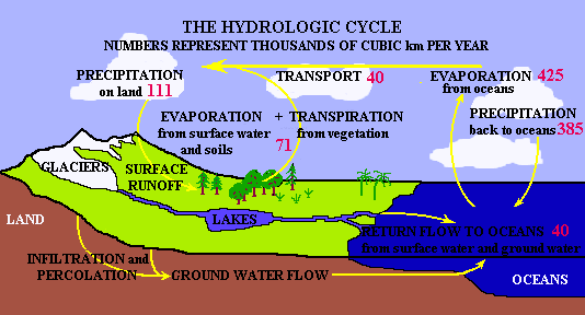 The hydrologic cycle in the Bat cave area is considerably simpler and, like any area,
can be quantified in a water budget equation. The area receives water from precipitation
and inflow from surrounding areas. It loses water through evaporation and transpiration
and from outflow to other areas. Some of the water may be stored in lakes or ground
water, and this stored amount may increase or decrease during wet or dry years. Some
water is also used by us (consumptive use) and is not returned to the local system..
Rainfall
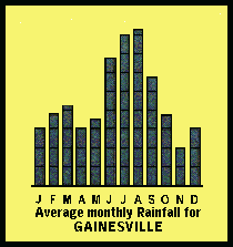 Annually, Alachua County receives some 54 inches of rainfall. June-September are the
wettest months. The least rainfall occurs in November. Most of the winter rainfall
is associated with cold fronts. In the summers months rainfall is associated with
convective thunderstorms and tropical storms and hurricanes. Rainfall pH in the area
is between 4.6 and 4.7.
Evapotranspiration
Evapotranspiration is around 34.5 inches/year, leaving a surplus of nearly 20 inches. There are no lakes and streams (surface waters) in the area because all the sediments and rocks in the area are highly porous and permeable. Therefore, all the water that does not evapotranspire actually infiltrates into the underlying Floridan Aquifer, which is the main aquifer (ground water reservoir) and source of water in Florida.
Storage
This area is an area of high recharge to the Floridan Aquifer. The main rock unit of this aquifer in the area is the Ocala Limestone, and the underlying Avon Park Limestone. In this area, the Ocala Limestone is very close to the surface. There are but a few feet (<20') of sediments that overlie the limestone. As you can see as you descend the staircase, in many places the limestone virtually outcrops at the surface.
What happens to the water in and around Bat Cave?
The general land elevation at the site is around 80-90 feet. While the elevation of the potentiometric (water table) surface varies over time, being lower in drought times and of course higher during wet periods, it generally ranges between 35' and 40' MSL near the cave. In the aquifer, water flow is both diffuse, where the water filters between the grains in the rock and conduit flow where water flows along enlarged openings in the limestone such as lineaments and fractures. Water flow in this part of the county is actually towards the northwest, generally heading towards the Santa Fe River into which it discharges. No doubt as the area becomes more developed, increasing mounts are discharged through wells. Although some of this inflows again from irrigation, septic tanks etc, much is also evaporated.
The great importance of the Floridan Aquifer as a water resource (it is the main source of potable water in the area) and the fact that this is an area of constant inflow (recharge) has led to increased concerns about the effect of human activities on the water supplies contained in the aquifer. For a long time, concerns mainly focused on industrial and urban activities. In contrast, little concern was expressed about the effects of human activities in rural areas, because of the low population densities. However, in the last three or four decades, we have come to realize that agriculture and other low density land uses can have as pronounced an effect on water quality as urban and industrialized areas. More on aquifer pollution
The water must be acidic
For water to be able to attack carbonates, it must be acidic. How does water become acidic?
- Atmospheric contamination
As water comes in contact with CO2 (carbon dioxide) in the atmosphere and in soils, water combines with carbon dioxide to make carbonic acid. Carbonic acid is a weak acid. Given the small amount of carbon dioxide in the atmosphere(~0.03%), we would expect rainwater to be mildly acidic (pH 5.5). But actually, the pH of rainwater is 4.8. In other words, rainwater is more acidic than expected. That's because CO2 in the atmosphere is not the only gas that affects how acidic precipitation becomes. Air pollutants such as sulfur and nitrogen oxides (produced by human and natural activity such as volcanos) also combine with water to form sulfuric and nitric acids and therefore add to the acidity of rainfall, i.e. lower its pH. As we continue to increase the amount of pollution we produce, we can expect that precipitation will become more acidic, significantly increasing solution rates over those we would expect to occur "naturally". - Soil contamination
As water continues its journey and infiltrates the soils, it further reacts with soil CO2 and becomes even more acidic. Some of this soil CO2 comes from bacteria and other micro-organisms that metabolize organic materials. Also, if the soil is rich in organic materials and therefore carbon, this carbon will combine with oxygen from the atmosphere to produce CO2. Because of bacterial activity and oxidation of carbon in soils, there can be 50 times more CO2 than in the soil than in the atmosphere. In addition, there are dissolved organic acids in the soil (e.g. tannic acid) which also contribute to acidity. The end result of all of these acid producing reactions is that the pH of waters in the soil or in the surficial aquifer may be as low as 3 and it is this acidic water that dissolves carbonates.
This acidic water must be able to reach the carbonate rocks.
Areas where the water easily reaches the limestones either because the cover is thin, or permeable (such as sands) or where there are pathways that allow water to flow faster such as cracks in the rock layers (faults and joints) are all places where solution takes place at a much greater rate. In places where the limestone is better protected by greater thicknesses of less permeable materials such as silts and clays solution happens at a much slower rate.
Where does this happen most?
Like all natural processes, rates of solution and lowering are not the same in all places, and how fast solution happens depends on local conditions.
Greater amounts of solution occur in areas of recharge. Recharge areas are areas where surface waters (rainwater and occasionally stream water) infiltrate and replenish ground water as they inflow to deeper aquifers. As acidic water percolates downward in recharge areas it chemically attacks the limestone, most commonly near the top of the water table. It is much less active in discharge areas (areas where water is lost from ground water (such as in springs for instance) because these waters have already reacted with the carbonates and have lost their acidity and are now neutral or slightly basic. Keep in mind that lots of factors (such as changes in sea level) can change the areal extent of recharge areas.
Greater amounts of solution take place where the flow of acidic waters is concentrated
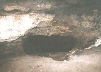 In zones where water flow is greater such as along joints, fractures, faults and along
bedding planes (surfaces), carbonates are in contact with greater quantities of acidic
waters, and solution will concentrate its effects along these areas of greater flow
.
In this picture taken in the main room of Bat Cave, note how acidic ground water has
concentrated its activity along bedding surfaces in the limestone creating what seems
to be layers in the cave.
Greater amounts of solution happen where fresh and salt water are mixing along the coasts.
It turns out that if you mix fresh and seawater (between 4-45 % sea water), even though
either the fresh and the salt water by themselves would not lead to solution, the
mix of the two will actually dissolve some of the limestone. This is going on today
in coastal areas, and, because sea level has fallen and risen repeatedly in the past,
such mixing zones are much more prevalent in the state than just in present coastal
areas.
Average rates of solution vary tremendously, even locally, from virtually none to
rates as high as 1cm/100yrs. While this may not seem much, remember the length of
geologic time during which erosion operates.
Caves can also form in lava flows (which of course is not an issue in Florida). But that method of cavity formation is totally different and not related to solutional karst processes.
Let's talk some chemistry
Calcium carbonate comes in two different minerals: aragonite and calcite. These two minerals have the same kind of atoms in them, CaCO3 (meaning 1atom of Calcium, Ca; one of Carbon, C; and 3 of Oxygen, O) but the atoms that they are made of are linked together differently (internal crystalline structure). Most of the original limestone deposits were made of aragonite, which is less stable than calcite. Usually, aragonite will change to calcite over time, or this aragonite may get dissolved. Another change that happens commonly is that both calcite and aragonite will get replaced by dolomite [CaMg (CO3)2] and silica (SiO2).
How and why solution happens
Simply stated, acidic waters dissolve carbonates. How do these natural waters become acidic?
As water comes in contact with CO2 in the atmosphere and in soils, they combine to make carbonic acid:
Carbonic acid is a weak acid. Given an atmospheric concentration of CO2 of 10-3.5 atmospheres, the expected acidity of rainwater is 5.5. But in realty, it is 4.8. That's because CO2 in the atmosphere is not the only culprit. Air pollutants such as sulfur and nitrogen oxides (produced by human and natural activity such as volcanos) also combine with water to form sulfuric and nitric acids and therefore add to the acidity of precipitation, i.e. lower its pH. As people continue to increase the amount of these oxides that they produce, it is expected that the pH of precipitation will continue to lower (meaning precipitation will become more acid), significantly increasing weathering rates over those we would expect to occur "naturally".
Additional acidity comes from organic activity in soils. As microorganisms metabolize organic materials, they form CO2 as a by product of metabolism. CO2 can also be produced by inorganic oxidation of organic materials. Partial pressure of CO2 in those environments can be as high as 10-2 atmospheres (up to 50 times higher than in the atmosphere). As rainwater infiltrates the soil, it reacts with this soil CO2 and the pH decreases again. In addition, there are dissolved organic acids in the soil (e.g. tannic acid) which also contribute to acidity. The end result of all of these acid producing reactions is that the pH of waters in the soil or in the surficial aquifer is commonly between 3 and 5.
Carbonates are especially sensitive to acidic solutions. When acidic water reaches limestone, the following reaction takes place:
As the Hydronium ions are "used up" in the reaction, the carbonates dissolve away and the pH rises to between 7 and 7.5. This leaves a void where the carbonate molecules used to be and the more insoluble (non-carbonate) parts of the layer are left as a residue. This residue is often rich in phosphatic or silicate materials such as clay, sand, silt, and usually rich in aluminum and ferric iron.
What are the Effects of Solution?
It erodes (wears away) the land.
The net effect of all this solution is that it lowers the land surface at an average rate of about 2 inches /1000 years. This does not sound like much, it's only a foot every 6000 years. The area around the cave is less than 100 feet above sea level. If present rates of lowering were constant, it would only take a little over a half million years to bring the area around the cave down to sea level. If we think of the Newberry area as being a young person 20 years old ( and geologically speaking Florida is young) its projected life expectancy would be a mere 3 months.
As it erodes land, it creates a unique landscape called a Karst Landscape
A karst topography is any topography or landscape that has developed by ground water erosion. It is characterized by
- caves (underground cavities either above or below the water table),
- sinkholes (depressions in the surface),
- solution valleys (merged sinkholes) and
- disappearing streams. (streams that flow at the surface for a while and then flow into a sink).
- lack of surface drainage. In areas where the cover over the limestone is permeable the water infiltrates the sediments and there may be no surface drainage at all.
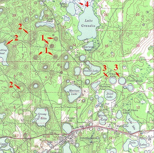
This is a section of the USGS 15 minute 1949 Interlachen quadrangle.
- #1 on the map indicate four of the many sinkholes that dot the landscape
- #2 are solution valleys or basins
- #3 are solution lakes, that occur wherever the sinkholes are deeper than the water table.
- #4 is a large solution basin that has been invaded by vegetation to form a swamp.
Note the complete absence of streams in the 25 mi2 area depicted.
There are basically four (4) different types of sinkholes in Florida.
Collapse sinkholes
This occurs in areas where there is extensive cover materials over a limestone layer. When solution creates a hole in the limestone and the limestone roof over the cavern either dissolves or no longer can support the weight of the overlying materials, these cover materials collapse into the cavern, leaving a funnel shaped sinkhole, usually circular in outline. In sands, these funnels will have gentle slopes, while in cohesive clays or in rock, the sides will be nearly vertical. If the overlying cover is clastic sediments it is called a cover collapse sink. If it is limestone, it is a rock collapse sink. The best known example of a rock collapse sink is the Devil's Millhopper State Geologic Site near Gainesville. Commonly, the formation of collapse sinkholes is sudden and catastrophic. These collapses are often affected by human activity, especially those that affect the hydrology of an area.
Solution Sinkholes
These sinkholes form more slowly and gradually as a result of enlargement of joints by solution. Eventually the rocks may settle and the cover material washes into the cavern in a process called raveling. These sinks are not as potentially impacted by human activities as are collapse sinkholes. Most commonly, it is changes in the hydraulic conditions in the aquifer (either natural or man-induced) that lead to raveling and solution sinkhole activation.
Alluvial Sinkholes
Older sinkholes partially or entirely filled with sediments due to subsequent marine deposition or by materials washed in from the sides are called alluvial sinkholes. Where the water table is shallow, they are often indicated by ponds, wetlands or cypress domes.
Raveling sinkholes
The above alluvial sinks may become reactivated when the aquifer levels rise or drop. Lowering of the aquifer levels creates a loss of buoyant support; increasing the water content of the plug such as happens when the water levels rise, increases the load and decreases the cohesion of the sediments. Other factors also come into play: vibrations, puncturing the plug with a well or other activity may cause the plug to fail by erosion and upward piping failure. When the sediments are no longer supported, the plug rapidly collapses.
Erosional Features
- General lack of surface drainage or, if there is drainage it is commonly internal (within closed depressions)
- Sinkholes also called dolines. There are four types of sinks recognized in Florida:
- Solution sinks (often shallow and w/gentle slopes) when limestone is near the surface
- Collapse sinks (deep and steep-sided) when the roof of caves collapse. Collapse sinks commonly form in association with changes in the water table such as severe droughts, significant rain events or increased water withdrawal. Deep, circular sinkholes with nearly vertical walls that extend below the water table are often called cenotes.
- Alluvial sinks, and
- Raveling sinks.
- Caves
- When sinkholes grow together they form a karst valley, an elongated depression that may grow to several miles in size
- Where the water table is below the surface, rivers flowing in karst plains disappear in sinks and caves; such streams are called disappearing streams or stream to sink topography. If the river had a well developed valley, this valley will terminate abruptly at the point where the stream disappears and is called a blind valley.
- From the point where this surface water is swallowed, the water now flows in passageways as an underground stream. These underground streams which occasionally resurface in springs and river rises (O'Leno State Park is such an example, where the Santa Fe River disappears only to rise again downstream). Sometimes also, the roof over the underground river pathway collapses, resulting in a river once again at the surface but now channeled within steep walls. In places where the roof over the river is left standing, you get natural or rock bridges. In some cases the old river valley, carved when that stream flowed at the surface in the past, no longer carries any water because all the drainage is now underground and has become an abandoned valley. View a map of O'Leno showing most of these features
- If sinks become plugged with less permeable clayey or silty materials, water will accumulate in the depression creating perched lakes and ponds that last till the obstruction is washed away. This is true on a small scale as well as a large scale. For example, solution created a karst basin south of Gainesville called Payne's Prairie. It was drained by a sink (Alachua sink) which clogged in 1871, creating a 32 sq mi lake. Some 20 years later, the debris washed away into underlying solution cavities and since that time it has again been Payne's Prairie.
- When karst depressions or the surface of the land intersect the water table, the outflowing ground water may create springs, rivers, and lakes.
When sinkholes intersect, cockpit karst close spaced depressions and conical hills( the Arecibo radio telescope is located in one such sinkhole in cockpit karst in Puerto Rico.). Tower karst is a more extreme form of cockpit karst. As solution continues, the sinks get deeper and deeper until a layer resistant to solution is reached. From this point, solution can only proceed laterally. As the sinks coalesce, they create a limestone plain from which rise more resistant towers of limestone, up to 650' tall (Guilin, China).
Maps
Western Valley in Western Alachua
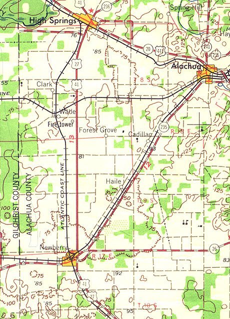 Approximately 180 mi2 (some12 mi wide x 15mile long) section of the Western Vally
in Western Alachua County, including a small part of the Brooksville Ridge. Bat Cave
lies in the lower third of the map near the Alachua/Gilchrist county line. Note the
virtually total absence of stream drainage, excepting a small part of the Santa Fe
River in the upper left hand corner of the map. (USGS 1:250,000 Gainesville, Fl. Quadrangle).
Arredondo Florida Map
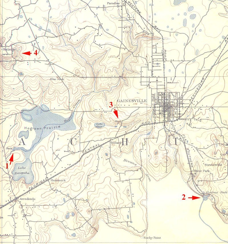 This is a segment of the USGS Arredondo, Fl 1:62500 15 minute Quadrangle. It was surveyed
in 1890 and published in March 1894. As you can see, there have been some major changes
in the Gainesville area in the last century! The red arrows highlight four examples
of disappearing streams. The largest of these (#1) is a sink in Hogtown Prairie wherein
disappears Hogtown Creek. Arrow #2 marks Alachua Sink a major sink at the northern
edge of Payne's Prairie. The blue line that runs southeast from the sink is Prairie
Creek which carries water from Newnan's Lake (off this map to the northeast) into
the sink. Water from numerous creeks that drain the edge of Payne's Prairie (note
Biven's Arm and Sweetwater branch in the center near the bottom) also empty into Alachua
Sink. #3 is Lake Alice and an unnamed small creek near it. They both disappear into
sinkholes. #4 represents several stream to sink features that drain a closed solution
basin.
O'Leno State Park Map
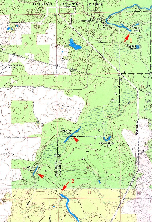 This is a composite of parts of two topographic quadrangles (Mikesville and High Springs,
Fl) showing the course of the Santa Fe River. The river sinks in O'Leno State Park
(arrow #1). From there it travels underground in caves and passageways to resurface
at River Rise near the bottom of the map (arrow #2). Downing and Black Lakes (un-numbered
arrows)are parts of the river's underground course where the roof of the passageways
have collapsed, exposing the river briefly.
In the open air of the cave, some of the water may evaporate from the carbonate rich solution and increases the concentration of dissolved bicarbonate. Eventually, it becomes saturated and carbonate begins to precipitate. Alternately, the CO2 dissolved in water can come out of solution increasing the pH of water. Either or both of these processes cause previously disolved carbonates to precipitate on surfaces and to build up limestone deposits. The material deposited by ground water is called travertine or more informally, dripstone. Cave features or formations that are formed from dripstone accumulations are called speleothems that may grow as much as 1 cm/year under favorable conditions.
If the water in the pools is constantly agitated, as from drips, cave pearls begin to form as carbonates precipitate on limestone particles in the pool, which act as seed grains. The constant motion of the water in the pool prevents the "pearl" from attaching to the sides of the pool but not from growing as additional travertine layers are added to its surface by precipitation.
They are as varied and unique in their expression as caves are. Some of the more common speleothems are:
Stalactites
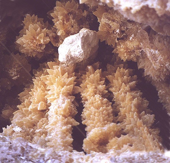
stalactites (hanging from the ceiling like icicles);
Stalagmites
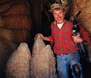
stalagmites, generally blunter than stalactites and rising from the floor;
Columns
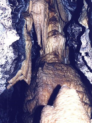
columns, which form when stalactites and stalagmites grow together;
Soda Straws
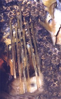
soda straws, thin, hollow stalactites from which probably all stalactites form originally;
Helictites
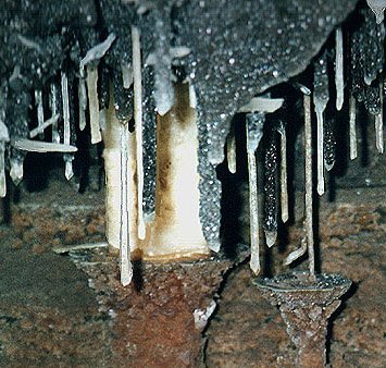
helictites where the water passes through the center by capillary action rather than gravity flow. Consequently helictites look like twigs and can grow in any direction.
Cave Popcorn
cave popcorn forms from travertine precipitating as water moves to the surface of a speleothem and evaporates from small openings.
Draperies
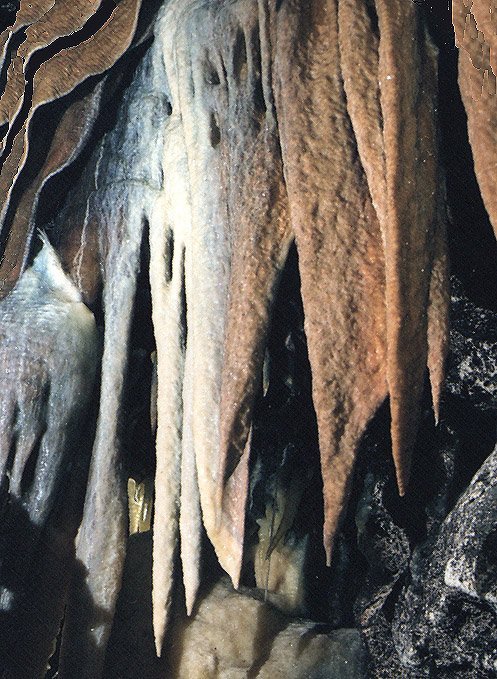
drip curtains or draperies form as water comes through a crack or joint and forms a linear curtain of stalactites;
Rimstone
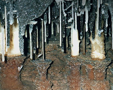
Along the edges of pools, rimstone will form as water evaporates; it may also form along the edges of stalagmites within the pool and create pedestals.
Bat Cave lies in a mainly agricultural region where the Floridan Aquifer, virtually the sole source of potable (drinking) water in all of North-Central Florida, is recharged by infiltration of precipitation. Every person uses nearly 200 gal. of water per day. This amounts to about 70,000 gal/person/year that must be pumped, treated and delivered to each of us that lives around here. As the population of Florida increased in the latter part of the last century (and continues to do so), concerns about the quantity and quality of available ground water became vital.
The Floridan Aquifer acts as a giant water savings account for the people of Florida. If you do not want to deplete your savings, your deposits (the part of rainfall that infiltrates) must be as large or greater than your withdrawals. Should part or all of your assets become frozen (such as when water becomes polluted) you may be able to use only parts of it, or in extreme cases none at all.
There is not much that we can do about rainfall. But we can do much about making sure that we conserve as much water as possible and that the water that recharges the aquifer is as uncontaminated as possible. For a long time, the focus of concerns about aquifer contamination put the spotlight on point sources, in other words, places where we could clearly see where the pollution originated from. With the increased awareness of the insidious effects of many chemicals on living things, (think of DDT as just one example) we have become much more sensitive to non-point sources of aquifer pollution.
Because there are virtually no clays in this area to slow down and filter inflowing water, contaminants in the area percolate through the thin sandy soils with little or no filtration, or they mainline into the aquifer through sinkholes, cave entrances, fractures and joints. Once in the underground aquifer, they can travel fast and far through solution-enlarged passages (conduit flow).
What are some of the pollutants of major concern in rural areas?
They consist of:
- Nutrients
Nitrates, for example, are a significant pollutant with bad health effects. Fertilizers rich in nitrates easily enter ground water, especially if too much is applied, or at the wrong time. Manure also contains nutrients that will percolate from areas where livestock or wildlife is allowed to or forced to congregate; extreme examples of this would be dairy farms, feed lots, chicken coops and hog farms. Another problem is due to allowing livestock access to sinks and cave entrances. Bird rookeries are significant nitrate contributors. Outhouses and improperly working septic tanks also add to the load. There is a direct relationship between land use and nitrate pollution. - Pesticides
Since WWII there has been an increased use of pesticides nation-wide. They are used for many functions, from killing weeds and insects, to controlling diseases. They are usually applied in some form of solution. Like nutrients, most pesticides infiltrate into ground water after rainy episodes where they definitely affect the drinking water. In caves and springs they can kill fish and crayfish and other cave life. They will also affect the bats either directly or as they consume contaminated insects. - Bacteria and viruses
Bacteria and viruses come from animal and human wastes, either by infiltration or when dead animals and wastes wash, fall or are thrown into sinks and caves - Sediments
Sediments that wash into solution features can carry nutrients, pesticides, pathogens and other pollutants to ground water. They fill solution passages, alter underground drainage patterns, and cause ground water to be turbid. - Other Contaminants
We have become aware of an increasing list of contaminants due to human activity. For example, salts in ground water can come from animal feeds and irrigation. Contamination comes also from improperly disposed fuels, oils, from leaking tanks, discarded cans and containers; discarded equipment (junk); chemical and household wastes, septic wastes, spills etc.. It used to be common practice to dispose of used motor oil by pouring it at the base of fence posts. While this worked very well to protect the posts from termites, bacteria and fungi that cause rot, it introduced significant amounts of hydrocarbons in the water supply. For the longest time also, sinkholes and caves were considered convenient private and semi-public dumps, contributing in no small measure to pollution. And this is but a small part of the entire list.